Thursday, May 26, 2011

THE BOYS FROM BEDFORD - OMAHA BEACH REMEMBERED


As another anniversary – this one the 67th – of the event we call “D-Day” passes by on the unfolding calendar of history, it is worth pausing to consider the profound impact this moment of time continues to register across the nation; and in some places more than others.

Operation “Overlord”, the long-anticipated and extremely chancy Allied invasion of the European continent on June 6, 1944 was given no more than a 50/50 chance of success by its planners, even before stormy weather on France’s channel coast made matters much worse.

In sheer numbers, the base of the sword aimed at the five target beaches of Normandy at 6:30 am that June morning remains mind-bending from any perspective: 5000 ships from 8 Allied navies, carrying 160,000 combat-ready troops and 30,000 vehicles supported by 11,000 aircraft, and an unprecedented year of focused and secret planning, training and preparedness. At the tip of that sword, and aimed at the critical and heavily-defended five-mile-long stretch of beach designated by the code word “Omaha”, was the untested 29th U.S. Infantry Division. Leading the first wave of that force were the men of the 116th Regiment, and at their forefront, the troops of Company A, a “brotherhood” of former National Guardsmen from the small rural Virginia town of Bedford.

Dating back to the days of colonial America’s first militia elements, there has existed in our country and in all our wars a tradition of recruiting fighting units by community; individual companies, entire regiments and even brigades, enabling volunteers to organize, train and eventually fight together. In fact many war historians will point to this phenomenon as an explanation of the high level of fighting efficiency noted in units of the National Guard in times of national emergency. (My own father in WW I served in a company of U.S. Marines who grew up together in a small Washington county, himself wounded coincidentally in France and on the same day – June 6th – but 26 years previously.)

In the 1930s, the mountain town of Bedford, Virginia was struggling to recover from the depths of the Great Depression as was so much of rural America of the time. Training with the National Guard not only gave young men an opportunity to wear a uniform the girls went for and perform useful service, but to earn the very attractive “dollar-per-day” which sweetened the chance to spend time with friends, neighbors and classmates at the nearby Armory, and on summer maneuvers. Brothers Clyde and Jack Powers, Raymond and Bedford Hoback, and the twins Ray and Roy Stevens had always enjoyed doing things together, and training with A Company of the 116th was a natural carry-on. For Pride Wingfield and Paul Schenk, it was a continuation of a close friendship which had followed them through their school and growing-up years, and would help to wile away the days of pre-invasion training in England where they would bicycle together through the countryside.

Taylor Fellers had been one of the first to become a Guardsman back in 1932, and by 1944, he was the Captain who would lead his younger townsmen onto the deadly beach, along with 1st Lt. Ray Nance and now Master Sergeant John Wilkes; serious men who had learned how to soldier; friends and “brothers” all.

When they surged over the edge of the British troopship Javelin and into their landing craft in the early morning dark, they each carried a 60-pound combat pack, and the knowledge that as a part of the first wave, their chances of surviving even the first few minutes would be slim. They would be right.

Twenty-two sons of Bedford Town would lose their lives that day, nineteen of them in a span of a few minutes; a larger percent of one town’s population than at any time or place in the course of WW II; Taylor Fellers, both Hoback brothers, Jack Powers, John Wilkes, John Shenk and Ray Stevens among them. Ray Nance would be the only Company “A” officer to survive Omaha Beach, and only Bob Slaughter would still be fighting when the war in Europe ended.

Only six Bedford boys walked away from Omaha Beach, but it would be stretching things to think they were unscathed. In all, the 116th regiment suffered 797 casualties.

Back in rural, green and beautiful Bedford, Virginia, population 3,000, the whole town mourned and many families treasured up the photos and memories they had wisely stored away. Today, Bedford is home to the official U.S.D-Day Memorial.

NOTE: The experience of the Bedford boys inspired the story and film “Saving Private Ryan".

.

A Company of U.S. soldiers huddle in their LSP (Landing Ship Personnel) with Omaha Beach and its unrelenting gunfire in sight.

U.S. Navy photo

Caption for Title Photo:

The U.S. Military cemetery at Normandy occupies high ground overlooking Omaha Beach today. 9,387 Americans are buried here on a piece of French soil that is held in title by the U.S.A.. Before the battle for Normandy officially came to a close on July 24th, 1,323,000 Americans had taken part, with casualties exceeding 120,000


Tuesday, May 17, 2011

CAPTURING GLIMPSES OF REFLECTED GLORY

Making a photographic image has been likened to capturing a split second of time and freezing it in that instant forever. Whatever the subject matter, the chances are that exact combination of lighting,
timing and composition has never occurred before, and will never happen again. Not only does this truism apply to action scenes, but to everyday visual phenomena.
As I travel this land I love with notebook, sketch pad and camera close at hand, I am constantly being reminded of the power of the unexpected; the magic of serendipitous moments, and the sheer beauty of nature caught in the act. I have been particularly dazzled by visual fragments of reflected glory; those isolated and elusive moments where something ordinary becomes extraordinary when seen “in duplicate”.
There was a period of time when I lugged a heavy and bulky 4X5 view camera and accessories into the field, often spending many hours just getting set up to make a single image on expensive film, only to be thwarted by a weather change or some other unexpected intrusion. Fortunately, I found sufficient compensation in the adventure of it all. (I enjoy one enlargement hanging on my wall, knowing that I returned to that one location each autumn for four years before achieving my photographic goal!)
Often I would end up discovering something entirely unexpected, like the day I spent hours trying – in vain – to find the desired angle from which to photograph a certain Vermont covered bridge, having traveled many miles to get there in the first place. What I captured instead was the reflection of a 19th century red barn in a setting I could never have planned, with the covered bridge ending up as a mere piece of background; a secondary subject.
With the birth of the digital age and the “point-and-shoot” technology available today, all that is needed for even the casual photographer to bring home such images of “reflected glory” is an eye for the unusual, and a talent for composition.


The northern Vermont village of Montgomery lays claim to five covered bridges, more than any other New England town that I know of. While all are historically interesting and visually appealing, they are not necessarily photogenic. In this case, it is the reflection which makes the moment so memorable.


There are rules of geometry which add interest to the photography of reflections: for instance the reflection is always the exact dimension of the real-time object, and the distance between subjects above and below the “mirror line” will be equal. Often a ripple or two in water will add both interest and context to the photo.


The last glacier to recede from northern New England did so around 15,000 years ago (not long in geologic time), leaving behind the striations and gouges in ancient granite which draw leagues of photographers to the mid-coast’s Pemaquid point. What made this visit different was the unusual combination of pooling rainwater and reflective light catching the image of the nearby lighthouse and buildings.


Cattails, lichen-painted stones and autumn leaves bring beauty to a woodland reflective pool.

TWO HUNDRED-FIFTY YEARS OF “AMAZING GRACE”

If you are a Civil War history buff, you might associate the name Mt. Weather with a strategic mountain top fought over several times as a lookout point by both North and South; if a serious traveler, you might just know it as a place on the map of Virginia in the Blue Ridge mountains about fifty miles west of Washington D.C. right next to the West Virginia line. If you are something of a conspiratorialist, you might recall articles describing the place as “Doomsday City”, or something similar. Actually, you would be right on all counts.
First constructed during the Cold War as an “Alternate National Capital”, it is –among other things – a vast, hardened, underground facility equipped to keep our government working in any kind of calamity or disaster, complete with a subterranean infrastructure. It is, in short, one of the most protected and secret sites in America. I cite these facts to underline the sense of aloneness and isolation I felt during a one-week stay there a few years ago in the course of anti-terrorism and weapons-of-mass-destruction training. Our small handful of emergency planners and responders from “the outside world” were restricted to carefully-marked walkways, corridors and buildings, and our quarters, while adequate, were almost reclusive.
One evening, I had repaired to my second-floor room when I heard the skirling notes of a bagpipe – a sound which has always struck a responsive chord in my inner being. I descended the stairs, and popped my head outdoors, not at all sure whether I might merely be hearing someone’s radio or tape recorder. My heart began to take special notice as I recognized the familiar notes of “Amazing Grace”, a favorite of every piper I had ever known. At last sure of direction, I strolled a ways down one of the few roadways not marked “off limits” to us, and into view came the figure of a fellow student from Utah, standing alone on a patch of lawn, playing his heart out. One by one, a few others from our small cadre joined us, sitting on a piece of nearby curbing or tree stump, surrounded by the emptiness of the secret underground city beneath our feet, mesmerized by the unexpected magic of the music. Not just any music, but one of the most beloved of American hymn songs for more than two centuries. Especially revered by members of the military, and often played as well at the funerals of police and firefighters, it is generally looked upon as “American as apple pie”; part and parcel of our unique cultural heritage.
While the connection with frontier America is certainly true, with the words and music appearing in the hymn books of dozens of denominations dating back to the 18th century, the words are the gift of an English preacher named John Newton, an individual whose story reads like a piece of creative fiction. Born in London in 1725 the son of a ship’s master, he followed his father to sea, serving on the crew of a British man-of-war in the most harsh and brutal of environments. As punishment for an attempt to desert, he was consigned to service on a slave ship, eventually working in the English slave trade in Sierra Leone where he was subjected to humiliating abuse at the hands of the master he served. His personal epiphany came in the midst of a terrible storm at sea in May, 1848. So profound was the depth of the religious conversion which took place within him that night that he forever after counted his life as beginning on that night.
Burdened with an overpowering sense of guilt, he channeled his life into becoming an ordained minister in The Church of England and finding a way to redeem himself from what he saw as a sinful past forever blemished by an association with slavery. Unlike other preachers whose service was marked by an outward piousness, Newton presented himself as a repentant “sinner” seeking his own way back while reaching out to others. His little parish at Olney, Buckinghamshire attracted such a following that the building had to be enlarged. There he authored the words to as many as 280 hymns, and the “Olney Hymn Book” was born and found its way across the Atlantic to the New World.
Students of church music history are unsure of the origins of the music which became intertwined with Newton’s powerful words, but I for one would find a touch of eternal justice in the opinion that it came from a spiritual melody raised by the voices of some of those same black slaves.
Amazing grace! (How sweet the sound)
That sav’d a wretch like me!
I once was lost, but now am found.
Was blind, but now I see.


The vicarage in Olney, Buckinghamshire, England where John Newton often met with such fellow writers of verse as William Cowper, and where he wrote “Amazing Grace” around 1760.

ROOTS OF REBELLION Probing For Answers

If there was one southern state which set the pace in the national melt-down leading to the Civil War, it would have to be the Palmetto State. The South Carolina House of Representatives voted 169-0 for secession, and on December 20, 1860 they notified Washington that their state had officially left the Federal Union. This despite the fact that in the November general election, only 40% of the state’s electorate really appeared to favor this course. James Buchanan, the lame duck (and pro-slavery) President still occupied the White House, while Abraham Lincoln remained waiting in the wings in Illinois and silent on political issues as had been his practice since the election.
Less than three months later, on April 12th, 1861, it would be South Carolina militiamen who would fire on and capture Ft. Sumter in Charleston Harbor, bringing about the open warfare many on both sides had hoped to avoid. Within another sixty days of that bombardment, the final four states would join South Carolina and her other six deep-south neighbors to form the Confederate States of America.
To begin to understand why this particular state came to be the “cradle of the Confederacy”, we have to go back to the earliest days of this country’s colonization. At a time when America was being settled by The London Company and other English-based enterprises, South Carolina was a colony of Barbadians, that is, a “Company of Adventurers” based in Barbados. The East Indies, by the late 1600s, was where “the action was”, with fortunes being made by Spaniards, Portuguese and some enterprising Englishmen. Sugar, tobacco and other crops filled the holds of ships heading to Europe; ships which would return with cargoes of more slaves for an already-crowded island of Hispaniola. It was a group of these West Indian investors who obtained a charter from King Charles to colonize what would become South Carolina, naming the area’s deep water port “Charles Town” in gratitude. It was their plan to establish a plantation-based colony growing tobacco, sugar, cotton and other lucrative crops based on the surplus of slaves from Haiti and newly-arrived black Africans.
The swampy climate of the lowland region was especially unkind to Europeans, with malaria felling them by the hundreds, at the same time black slaves seemed impervious to the same illness. (Plantation owners would not have known that West Africans possessed a “sickle cell” which gave them a natural immunity.) Once it was discovered that rice would thrive in this wet and humid climate, the whole complexion of tidewater culture underwent a significant transformation. The Spaniards – England’s arch enemies – pretty much controlled the world’s major sources of rice, a grain so esteemed and even precious, that Italians attempting to steal rice seeds from that Mediterranean country’s Po Valley could face the death sentence.
The consequent transition from sugar to rice production required a labor force familiar with the intricacies of a very different form of agriculture, and a new dependency on experienced Africans from Niger and Senegambia. In time, upper class whites largely became “non-resident” plantation owners, and educated and literate members of the slave population rose to be resident managers.
There developed in South Carolina a unique form of highly-localized government based on the plantation system, and a feudal-like relationship between classes of society. At the base of it all was the largest slave population in the New World, with blacks outnumbering whites two- to-one statewide, and as much as nine-to-one in the tidewater regions.
In 1820, an activist free slave with military experience named Denmark Vesey planned an insurrection of black slaves and poor whites in the Charleston area. (Prior to that time, at least seventeen slave uprisings had occurred throughout the south.) Although Vesey and his followers were eventually killed and the plot put down, it left Carolinians with a growing contempt for abolitionists of all stripes and a high state of protectionism when it came to the institution of slavery. In fact, 90% of all slaves to come to America passed through the auction blocks at Charleston.
Although only one great battle and its attendant skirmishes would actually be fought on South Carolina soil, the state would pay a high price in blood for its fierce fight for independence. It is believed that somewhere between 30% and 35% of its fighting age men and boys (18 – 45) died in the four year conflict. No other state paid so dearly or fought more determinedly.
A Parting note: The concept of secession was not something new in South Carolina. The key battle of Secessionville in the Charleston campaign in June, 1862 marked the location of a much earlier secession fight over plantation rights.


The First National Flag of the Confederate States of America shows seven white stars in a field of blue with two broad red bars separated by one of white. At the time of its design, South Carolina had been joined by Mississippi, Alabama, Florida, Georgia, Louisiana and Texas – the so-called Deep South states. The Second National Flag would follow with eleven stars. This flag is the only CSA banner to be correctly known as “The Stars and Bars”. Photo & flag by Al Cooper

At the First Bull Run battle, soldiers from both sides were confused by the South’s “Stars and Bars” flag, because in the heat of the fighting it looked very like the “Stars and Stripes”. Thereafter, it was not ordinarily carried into combat although it remained the Confederacy’s official banner. In its place, the diagonal Scottish cross of the Battle Flag, in its several forms, was displayed. It became the most recognized – and presently controversial – symbol of the southern cause.

Wednesday, April 27, 2011

TIME MACHINES - SHADOWS ON THE LANDSCAPE


We have the Dutch to thank for the modern word landscape, one of those “borrowed” pieces of language which has taken on an enlarged meaning over the years. Holland, home to some of the greatest artists of the past, re- invented the word landshap to describe a painting style of the early 18th century which saw artists moving outdoors with their brushes and oils to record the beauties of field, stream and nature. The word literally meant “shape of the land”, so when it moved into English in the late 1700s, it began to find usage outside the realm of portraiture. Present day demographers in fact think of “landscape” in terms not just of the natural outdoor world, but of the land and its content as a dynamic and changing backdrop to people’s lives; including features made by man himself.
As I have traveled this land I love, with notebook, sketch pad and camera over a lifetime, I have sought to capture all that the word conveys. In this and some future columns, I will share some of what I have seen, in both images and words.
For thousands of years, agriculture changed little, production being limited to what one man with basic hand tools could plant, raise and harvest. A hard-working farmer with a hand-sharpened scythe for instance, might hope to harvest about one quarter of an acre of wheat per day, about what he could have planted while laboring behind a horse or an ox in a similar time span. Then, in the 1830s, an American “revolution” began. A young Vermonter named John Deere invented a self-cleaning, side-board iron-and-steel plow destined to change farming forever, at the same time a Virginian of Irish descent, Cyrus McCormick, patented a device known as a mechanical reaper. Suddenly, farm output quadrupled, freeing up entire segments of population to move into industry, literally changing American agricultural and the cultural landscape. From horse-drawn implements made from interchangeable parts, it was a short leap into a future powered by steam, then gasoline engines, all in time to open up the vastness of western prairie lands. The “shadows” of those marvelous and inventive implements still linger on the landscape, as graceful artifacts from our agricultural past.


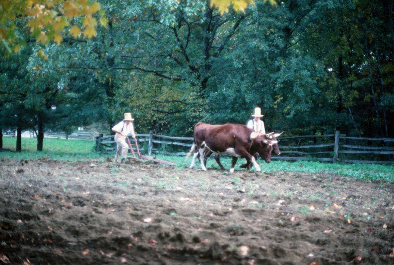
Old Sturbridge Village in Massachusetts – a true living-history museum – seeks to recreate everyday life in a typical northeastern village of 1800. If you are lucky, you might get to see high-hatted farmers using a yoke of oxen to open furrows in the same way it had been done for centuries of time.


Spring flowers and meadow grass are backdrop for a horse-drawn cultivator which seems to languish in the same spot where it probably met its demise years ago, replaced perhaps by a tractor-motivated machine of greater efficiency. Wherever the artist or photographer may wander, such “stories” are waiting to be discovered.


With iron locomotives and ribbons of steel spanning the continent, it was inevitable that the huffing and belching steam engine would find its way onto the growing acres of wheat lands in the mid-west. The Wood Bros. of Iowa produced steam-powered threshing machines such as this one, between 1910 and 1919. Far too expensive for an individual farmer to acquire, “threshing rings” made up of multiple families would be organized, with one member designated to be sent away to a steam school, so that an entire farming neighborhood could benefit from its bountiful potential.


Offspring of Cyrus McCormick’s revolutionary invention, and renovated with rubber-tired wheels and a tractor towing hitch, this harvester was originally pulled by a gang of horses, and was capable of harvesting 16 acres per day or more, literally changing history.

Caption for title photo above:
Like some giant mechanical dinosaur from out of a sci-fi drama, this still-colorful piece of farming history is one of hundreds of such Utah landmarks.

IN SEARCH OF A TRUE VILLAGE BAKER

I first met Ray Powers more than 25 years ago, personally selling his wonderful hand-crafted loaves of peasant bread from the tailgate of his venerable Volvo at a farmers’ market in Rutland, Vermont. The chance meeting was to become – for me – not only an important chapter in my search for brick hearth bakers around the country, but the beginning of a dawning realization that my own life has been enriched by touching shoulders with a pantheon of remarkable people who live life purposefully and with a special passion for what they do.
After that first day, I found my way to the top of a wooded country road outside Wallingford to the yellow-painted farmhouse where Ray and Christine Powers had settled to raise a family and bake old-world bread. I spent much of the next three days, warmed by the immense brick hearth attached to the renovated country home, observing the process which converted naturally-leavened whole grain loaves from starter to finished product, while absorbing the unusual personal story of the two lives united by this task they loved. Fired by lengths of dry and cured hardwood fed to a baking fire which was started at 4:00 AM, the mammoth brick hearth – built by an itinerant bricklayer from Maine who was himself plowing new and unexplored ground – the oven would reach an internal temperature of 800 degrees. The first batch of 100 risen loaves would take only 25 minutes to bake, as billows of steam would be added to develop a crisp outer crust from time to time, with Ray constantly moving the loaves to different places inside with his long-handled wooden peel to insure a uniform finish.
A second batch of 100 loaves would go in next, with a reduced temperature of 600 degrees requiring an added 10 or 15 minutes of hearth time, followed by a third and final batch, all going on as Christine moved the finished loaves to just the right spot on the cooling racks which circled the hearth room, and readying the next baskets of rising dough in their time.
With the day’s baking completed, the husband-and-wife team would use a slab of unbaked dough to leaven a new batch of dough turning slowly in their ancient mixing machine destined to cure for 48 hours before the next baking day, producing at least three variations including whole-grain rye, French-style baguette and raisin-filled wheat loaves.
Warmed by the tons of brick and wonderful aromas of baking bread which surrounded us, and the meeting of minds shared as we lunched on slices of rye and fresh-from-the-garden tomatoes, I listened to the unusual story of the shared dream which had given birth to it all.
When the two met – rather late in life – Ray was a Jesuit Priest teaching students in an English school in Bagdad, Iraq and Christine was herself a Catholic Nun. Dating back to the fifteenth century, the “Society of Jesus” – the Jesuits - is one of the oldest and most mission-oriented orders in the Catholic Faith, and it is unusual for a Father with the SJ after his name to leave the calling. Ray and Christine however had each arrived at a point in their lives where they felt inspired to seek a path which would allow them to have a family. With a release from the church hierarchy, they married and began a search for a place to live and a work they could share. They wished to live in a country environment, and to pursue an artisan craft which would benefit everyday people and provide a simple but satisfying sustenance. Journeying across Europe, they fell in love with the whole concept of village baking, tied to a history which was honorable and an ethic which was planted in long-established roots. In all their travels in America, they felt most comfortable in the Green Mountains of Vermont where they bought an abandoned farm on Bear Mountain.
I once asked Ray if they had found success in the life they were leading. He looked at me and said: “It all depends on what you call success. We are raising two wonderful and talented children, we live in a beautiful place and are engaged in an honest daily task we enjoy. Our home is paid for, we have no debt more than thirty days old, and we have our faith.”
In a world and at a time when we are told by experts that the average working adult will change jobs seven times in a lifetime, I am comforted to know and be uplifted by people like my friends, Ray and Christine Powers – true VILLAGE BAKERS.


Ray Powers removes finished loaves of country bread from his mammoth brick hearth oven at the time of an early visit years ago. Ray bakes three days each week, devoting the other days to selling and delivering finished product.


It is reassuring each year to find Ray and Christine Powers of “Bear Mountain Bakers” still selling their hand-crafted loaves at the Rutland, Vermont Farmers’ Market, this picture taken at the time of a recent visit.

FROM BULL RUN TO APPOMATTOX - NAVIGATING THE GEOGRAPHY OF THE CIVIL WAR

Driving south from Washington, D.C. on U.S. I-95 nowadays it takes just over an hour to reach the city of Richmond, Virginia, passing by places on the map with names like Manassas, Fredericksburg, and Spotsylvania. It stretches the mind of any first-time traveler to realize that for nearly four years mighty armies fought over and for this narrow strip of Virginia countryside dividing the two countries whose respective capitols were separated by those few miles. Ultimately that clash of arms and aims would involve most of the eastern part of the continent, touching the lives of virtually every American family with 3.5 million men wearing one uniform or another.
On a warm July day in 1861, no one could have foreseen such a future, even though the shots fired on Ft. Sumter had indeed lit the fuse. A newly-formed Confederate Army commanded by General P.G.T. Beauregard had encamped near the crossroads town of Manassas Junction, posing an obvious threat to the Oval Office itself, and rousing a response from Union General Ervin McDowell charged with responsibility for the defense of the Union Capitol.
On July 21st, 47-year-oldWilmer McLean, a local wholesale grocer and retired Major in the Virginia Militia, was sitting down to dinner with his family and their guest – Gen. Pierre Gustave Toutant Beauregard in their comfortable Manassas residence, when gunfire broke out in the front yard, a Union cannon ball actually falling through the roof and into the cooking fire. The occasion was the opening battle of the American Civil War, an engagement ever after known as “First Bull Run” to northerners, or “First Manassas” to Confederates. The prefix “First” became necessary, because just one year later, a “Second” battle would take place nearby (another win for the South, by the way).
Wilmer McLean, too old to return to active military duty and concerned for the safety of his family decided to move to a safer location, and so it was that four years later, they were relocated at Appomattox Courthouse – approximately 120 miles south of their former residence – when the war came to an end with the surrender of General Robert E. Lee and his Army of Northern Virginia. Once again, an oddity of which that war had more than its share took place when the two sides sat down and signed the famous surrender documents there in the McLean home. Thus, on April 9th, 1865 Wilmer McLean could say the war which began in his front yard had ended in his living room.
Bull Run/Manassas exemplifies one of the challenges facing any study of the geography of that vast struggle. Union chroniclers usually named battles for some feature of the battle field while those from the Confederate side usually referred to the name of a place on the map: Manassas was a crossroads town while “Bull Run” was the name of a creek which ran through the area. The North’s “Battle of Antietam” for Maryland’s Antietam Creek was the “Battle of Sharpsburg” to men of the Gray; “Shiloh” referred to a small church building, while the fight which took place there was “The Battle of Pittsburg Landing” in newspapers of the Confederacy.
There were literally hundreds of battles fought for control of transportation hubs, river crossings, railroad junctions, sea ports or simply for commanding and strategic points of high ground. Other costly engagements took place where no one had planned them, but because two great armies happened to meet, such as Gettysburg. Sometimes some tiny and seemingly unimportant piece of geography became associated with a denomination those who fought there would never forget, like Malvern Hill, Savage’s Station, Gaines’s Mill, Stones’ River, Yellow Tavern or Five Forks. (When I visit such out-of-the-way places even today, the shiver that runs up and down my spine reminds me that I am walking on hallowed ground.)
Because the media of the day devoted so much space to the relatively nearby drama being played out in that 100-mile stretch between Washington and Richmond (where the men in Gray dominated victory for much of the first two years), the public of neither side realized that the larger war was being won by the men in Blue out west. The little-known “Anaconda Plan”, advanced by the venerable General-In-Chief Winfield Scott at the outset of hostilities and quietly accepted by Abraham Lincoln was being played out. Fort by fort, mile by mile, Confederate supply lines were being rolled up as Union forces – on land and water – were taking control of the Mississippi, the Ohio, the Cumberland and the Tennessee, while the ocean Navy was making ever-more impregnable a blockade of Atlantic ports. Overseeing this western campaign was an unlikely candidate for any kind of fame; a failed Ohio shop-keeper and small-town businessman named Ulysses (Sam) Grant, about whom much more would be heard in the future.


Always an aristocratic gentleman, Robert E. Lee presents himself in full dress uniform with his sword for the surrender signing on April 9th, 1865 in Wilmer McLean’s parlor at Appomattox Courthouse. Ulysses Grant, dressed in rough and informal “field wear” is generous in his terms as men such as Gen. George A. Custer, and Capt. Robert Todd Lincoln (representing his father, the President) look on. As this tableau unfolded, Lincoln in Washington had only five days to live.


Much of the original McLean house disappeared into the pockets of souvenir hunters long ago. The historic landmark and its parlor have been reconstructed in detail, and appear today as seen here.


Winfield Scott understood that the Confederacy could be defeated only by total economic collapse when he shared with Lincoln a plan for the eventual encirclement of the South’s supply lines. The press of the day made fun of what they called the “Anaconda Plan” as in this cartoon. Events proved Scott to have been right.

Wednesday, April 13, 2011

BEACHCOMBING FOR SEA GLASS Nature's Vanishing Legacy


The years between 1890 and 1920 witnessed the “hayday” of commercial glass. The two beverage bottles were designed to be refilled, while cobalt blue was a favored color for patent medicine. The small, hand-blown perfume bottle is a rare collector’s item and a personal favorite.

Fifty years ago I made my first sea voyage, courtesy of Uncle Sam; a 17-day, typhoon-tossed crossing of the vast Pacific. For entertainment, I watched from the troop ship’s fantail each day as crew members tossed the day’s garbage overboard - a potpourri of what was left over from feeding and caring for 1100 reluctant and none-too-happy passengers. At the time, I gave little thought to the fact that I was seeing a reenactment of what had been going on for 2000 years of maritime history, and even less would I have pondered the unknowable system of digestion by which man’s detritus - mere morsels certainly - would be processed into food for the fish and algae of the deep.
Among the refuse committed to the depths on the world’s great sea routes, and especially along the busy coastal shipping lanes near our own shores, were such items as jars, jugs, bottles, crockery and glass containers of all kinds, colors, shapes and hues. For hundreds of years. Ships from Europe had been coming here for two centuries before the Mayflower, and glass manufacturing was itself the first industry established at Jamestown in 1608.
It should come as no surprise that at least some of those glass remnants should come ashore, after being shaped and polished, altered and refined by years, decades and even centuries of processing by the sea. Those who – like myself and my family – have become itinerant beachcombers have developed and nurtured a special love affair with what we think of as “gem stones of the deep”. Their unique history, voyage and place of discovery make each “find” a gift from antiquity whose exact genealogy is worth pondering and cataloging.
Glass manufacturing dates back 4000 years, to a time when it was discovered that a mixture of 75% silica sand, 15% sodium bicarbonate, and 10% lime would become a molten sheet when heated to 2400 degrees Fahrenheit. Around 250 BC glass blowing took the process into a whole new set of possibilities, and the transport of liquids changed commerce. A New Jersey factory began making glass bottles in moulds in 1739, although the process would not be automated until the early 1900s. Mould marks on old bottles help to tell their age, just as “waves” in window glass suggests early casting techniques.
The color and shade of glass is another key to age: the addition of cobalt oxide began in the 1890s producing glass ranging from aqua to light blue. The Phillips Company’s milk of magnesia bottles were marked by the dark blue of this chemical; Pre-1900 soda bottles were another example, as were some early milk and poison bottles. Coca Cola bottles were blue-green until 1920, when the demand for “clear” glass increased. Antique flasks, goblets and lantern globes were often red (chards of this color are the “holy grail” of sea glass collectors today, with the orange of “carnival” glass so rare, that one “find” in 10,000 is considered fair odds.)
The yellow of “Vaseline glass” and the turquoise or lavender of certain canning jars add color to anyone’s collection, while white “milk glass” shows up in the cap liners of old “Ball” preserving lids.
The color, shape and “frosting” of ocean glass fragments result from long exposure to such factors as hydration, leaching, de-vitrification, erosion, pitting and abrasion. Their surface may show “crazing” or “crizzling” (indenting), and they tend often to be triangular in shape from the rhythmic action of surf and tides.
Sea glass does not come ashore just anywhere, and collectors are apt to be people who study weather maps, tide charts, and the shore environment. Along a thousand miles of Maine shoreline, we have come to confine our search time to a very specific location on John’s Bay, and another near Marshall Point.
Now, in the age of plastic and its cousins, sea glass is a vanishing phenomenon, and every tiny glistening sliver of frosty crystal caught by a spring tide is a gift as valuable as a real gem stone.
NOTE: On Oct. 25, 1865, a side-wheel steamship, the S.S. Republic, en route from New York to New Orleans sank in a Hurricane off the coast of Georgia. In 2003 - 138 years later - divers found the wreck lying at a depth of nearly 1700 feet, 100 miles southeast of Savannah. Along with much silver and other artifacts, they found crates of glass perfume bottles bearing the mark of “Isaac Edrehi Co.” of New York City, many with the glass stoppers intact. One of those bottles would look good in my collection: Isaac Edrehi was my maternal great grandfather.


Assembled by color, these pieces of “sea glass” were collected over a period of years, each one with its own story. Pieces of blue or red glass have become extremely rare along the Maine coast.


The art of hand-blowing glass has changed little over the years. This modern-day artisan is preparing a glob of newly-molten glass to be blown and shaped into a goblet.


Factors as distant as the alignment of the earth, the moon and Jupiter have an impact on the tides which sweep ancient pieces of sea glass along the ocean bottom and onto a rocky beach. Receding storm tides are especially prized by beachcombers.