Wednesday, April 27, 2011

TIME MACHINES - SHADOWS ON THE LANDSCAPE


We have the Dutch to thank for the modern word landscape, one of those “borrowed” pieces of language which has taken on an enlarged meaning over the years. Holland, home to some of the greatest artists of the past, re- invented the word landshap to describe a painting style of the early 18th century which saw artists moving outdoors with their brushes and oils to record the beauties of field, stream and nature. The word literally meant “shape of the land”, so when it moved into English in the late 1700s, it began to find usage outside the realm of portraiture. Present day demographers in fact think of “landscape” in terms not just of the natural outdoor world, but of the land and its content as a dynamic and changing backdrop to people’s lives; including features made by man himself.
As I have traveled this land I love, with notebook, sketch pad and camera over a lifetime, I have sought to capture all that the word conveys. In this and some future columns, I will share some of what I have seen, in both images and words.
For thousands of years, agriculture changed little, production being limited to what one man with basic hand tools could plant, raise and harvest. A hard-working farmer with a hand-sharpened scythe for instance, might hope to harvest about one quarter of an acre of wheat per day, about what he could have planted while laboring behind a horse or an ox in a similar time span. Then, in the 1830s, an American “revolution” began. A young Vermonter named John Deere invented a self-cleaning, side-board iron-and-steel plow destined to change farming forever, at the same time a Virginian of Irish descent, Cyrus McCormick, patented a device known as a mechanical reaper. Suddenly, farm output quadrupled, freeing up entire segments of population to move into industry, literally changing American agricultural and the cultural landscape. From horse-drawn implements made from interchangeable parts, it was a short leap into a future powered by steam, then gasoline engines, all in time to open up the vastness of western prairie lands. The “shadows” of those marvelous and inventive implements still linger on the landscape, as graceful artifacts from our agricultural past.


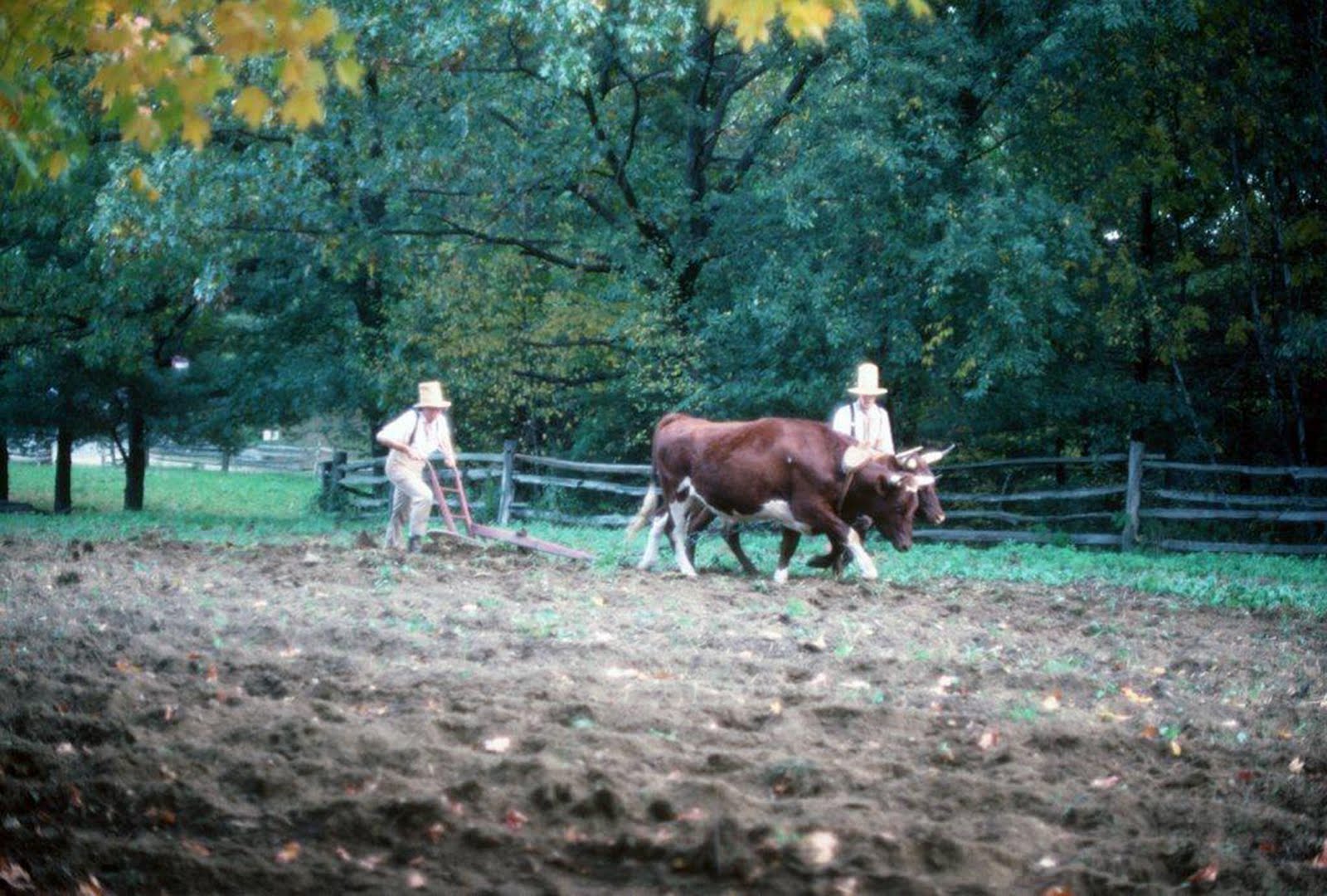
Old Sturbridge Village in Massachusetts – a true living-history museum – seeks to recreate everyday life in a typical northeastern village of 1800. If you are lucky, you might get to see high-hatted farmers using a yoke of oxen to open furrows in the same way it had been done for centuries of time.


Spring flowers and meadow grass are backdrop for a horse-drawn cultivator which seems to languish in the same spot where it probably met its demise years ago, replaced perhaps by a tractor-motivated machine of greater efficiency. Wherever the artist or photographer may wander, such “stories” are waiting to be discovered.


With iron locomotives and ribbons of steel spanning the continent, it was inevitable that the huffing and belching steam engine would find its way onto the growing acres of wheat lands in the mid-west. The Wood Bros. of Iowa produced steam-powered threshing machines such as this one, between 1910 and 1919. Far too expensive for an individual farmer to acquire, “threshing rings” made up of multiple families would be organized, with one member designated to be sent away to a steam school, so that an entire farming neighborhood could benefit from its bountiful potential.


Offspring of Cyrus McCormick’s revolutionary invention, and renovated with rubber-tired wheels and a tractor towing hitch, this harvester was originally pulled by a gang of horses, and was capable of harvesting 16 acres per day or more, literally changing history.

Caption for title photo above:
Like some giant mechanical dinosaur from out of a sci-fi drama, this still-colorful piece of farming history is one of hundreds of such Utah landmarks.

IN SEARCH OF A TRUE VILLAGE BAKER

I first met Ray Powers more than 25 years ago, personally selling his wonderful hand-crafted loaves of peasant bread from the tailgate of his venerable Volvo at a farmers’ market in Rutland, Vermont. The chance meeting was to become – for me – not only an important chapter in my search for brick hearth bakers around the country, but the beginning of a dawning realization that my own life has been enriched by touching shoulders with a pantheon of remarkable people who live life purposefully and with a special passion for what they do.
After that first day, I found my way to the top of a wooded country road outside Wallingford to the yellow-painted farmhouse where Ray and Christine Powers had settled to raise a family and bake old-world bread. I spent much of the next three days, warmed by the immense brick hearth attached to the renovated country home, observing the process which converted naturally-leavened whole grain loaves from starter to finished product, while absorbing the unusual personal story of the two lives united by this task they loved. Fired by lengths of dry and cured hardwood fed to a baking fire which was started at 4:00 AM, the mammoth brick hearth – built by an itinerant bricklayer from Maine who was himself plowing new and unexplored ground – the oven would reach an internal temperature of 800 degrees. The first batch of 100 risen loaves would take only 25 minutes to bake, as billows of steam would be added to develop a crisp outer crust from time to time, with Ray constantly moving the loaves to different places inside with his long-handled wooden peel to insure a uniform finish.
A second batch of 100 loaves would go in next, with a reduced temperature of 600 degrees requiring an added 10 or 15 minutes of hearth time, followed by a third and final batch, all going on as Christine moved the finished loaves to just the right spot on the cooling racks which circled the hearth room, and readying the next baskets of rising dough in their time.
With the day’s baking completed, the husband-and-wife team would use a slab of unbaked dough to leaven a new batch of dough turning slowly in their ancient mixing machine destined to cure for 48 hours before the next baking day, producing at least three variations including whole-grain rye, French-style baguette and raisin-filled wheat loaves.
Warmed by the tons of brick and wonderful aromas of baking bread which surrounded us, and the meeting of minds shared as we lunched on slices of rye and fresh-from-the-garden tomatoes, I listened to the unusual story of the shared dream which had given birth to it all.
When the two met – rather late in life – Ray was a Jesuit Priest teaching students in an English school in Bagdad, Iraq and Christine was herself a Catholic Nun. Dating back to the fifteenth century, the “Society of Jesus” – the Jesuits - is one of the oldest and most mission-oriented orders in the Catholic Faith, and it is unusual for a Father with the SJ after his name to leave the calling. Ray and Christine however had each arrived at a point in their lives where they felt inspired to seek a path which would allow them to have a family. With a release from the church hierarchy, they married and began a search for a place to live and a work they could share. They wished to live in a country environment, and to pursue an artisan craft which would benefit everyday people and provide a simple but satisfying sustenance. Journeying across Europe, they fell in love with the whole concept of village baking, tied to a history which was honorable and an ethic which was planted in long-established roots. In all their travels in America, they felt most comfortable in the Green Mountains of Vermont where they bought an abandoned farm on Bear Mountain.
I once asked Ray if they had found success in the life they were leading. He looked at me and said: “It all depends on what you call success. We are raising two wonderful and talented children, we live in a beautiful place and are engaged in an honest daily task we enjoy. Our home is paid for, we have no debt more than thirty days old, and we have our faith.”
In a world and at a time when we are told by experts that the average working adult will change jobs seven times in a lifetime, I am comforted to know and be uplifted by people like my friends, Ray and Christine Powers – true VILLAGE BAKERS.


Ray Powers removes finished loaves of country bread from his mammoth brick hearth oven at the time of an early visit years ago. Ray bakes three days each week, devoting the other days to selling and delivering finished product.


It is reassuring each year to find Ray and Christine Powers of “Bear Mountain Bakers” still selling their hand-crafted loaves at the Rutland, Vermont Farmers’ Market, this picture taken at the time of a recent visit.

FROM BULL RUN TO APPOMATTOX - NAVIGATING THE GEOGRAPHY OF THE CIVIL WAR

Driving south from Washington, D.C. on U.S. I-95 nowadays it takes just over an hour to reach the city of Richmond, Virginia, passing by places on the map with names like Manassas, Fredericksburg, and Spotsylvania. It stretches the mind of any first-time traveler to realize that for nearly four years mighty armies fought over and for this narrow strip of Virginia countryside dividing the two countries whose respective capitols were separated by those few miles. Ultimately that clash of arms and aims would involve most of the eastern part of the continent, touching the lives of virtually every American family with 3.5 million men wearing one uniform or another.
On a warm July day in 1861, no one could have foreseen such a future, even though the shots fired on Ft. Sumter had indeed lit the fuse. A newly-formed Confederate Army commanded by General P.G.T. Beauregard had encamped near the crossroads town of Manassas Junction, posing an obvious threat to the Oval Office itself, and rousing a response from Union General Ervin McDowell charged with responsibility for the defense of the Union Capitol.
On July 21st, 47-year-oldWilmer McLean, a local wholesale grocer and retired Major in the Virginia Militia, was sitting down to dinner with his family and their guest – Gen. Pierre Gustave Toutant Beauregard in their comfortable Manassas residence, when gunfire broke out in the front yard, a Union cannon ball actually falling through the roof and into the cooking fire. The occasion was the opening battle of the American Civil War, an engagement ever after known as “First Bull Run” to northerners, or “First Manassas” to Confederates. The prefix “First” became necessary, because just one year later, a “Second” battle would take place nearby (another win for the South, by the way).
Wilmer McLean, too old to return to active military duty and concerned for the safety of his family decided to move to a safer location, and so it was that four years later, they were relocated at Appomattox Courthouse – approximately 120 miles south of their former residence – when the war came to an end with the surrender of General Robert E. Lee and his Army of Northern Virginia. Once again, an oddity of which that war had more than its share took place when the two sides sat down and signed the famous surrender documents there in the McLean home. Thus, on April 9th, 1865 Wilmer McLean could say the war which began in his front yard had ended in his living room.
Bull Run/Manassas exemplifies one of the challenges facing any study of the geography of that vast struggle. Union chroniclers usually named battles for some feature of the battle field while those from the Confederate side usually referred to the name of a place on the map: Manassas was a crossroads town while “Bull Run” was the name of a creek which ran through the area. The North’s “Battle of Antietam” for Maryland’s Antietam Creek was the “Battle of Sharpsburg” to men of the Gray; “Shiloh” referred to a small church building, while the fight which took place there was “The Battle of Pittsburg Landing” in newspapers of the Confederacy.
There were literally hundreds of battles fought for control of transportation hubs, river crossings, railroad junctions, sea ports or simply for commanding and strategic points of high ground. Other costly engagements took place where no one had planned them, but because two great armies happened to meet, such as Gettysburg. Sometimes some tiny and seemingly unimportant piece of geography became associated with a denomination those who fought there would never forget, like Malvern Hill, Savage’s Station, Gaines’s Mill, Stones’ River, Yellow Tavern or Five Forks. (When I visit such out-of-the-way places even today, the shiver that runs up and down my spine reminds me that I am walking on hallowed ground.)
Because the media of the day devoted so much space to the relatively nearby drama being played out in that 100-mile stretch between Washington and Richmond (where the men in Gray dominated victory for much of the first two years), the public of neither side realized that the larger war was being won by the men in Blue out west. The little-known “Anaconda Plan”, advanced by the venerable General-In-Chief Winfield Scott at the outset of hostilities and quietly accepted by Abraham Lincoln was being played out. Fort by fort, mile by mile, Confederate supply lines were being rolled up as Union forces – on land and water – were taking control of the Mississippi, the Ohio, the Cumberland and the Tennessee, while the ocean Navy was making ever-more impregnable a blockade of Atlantic ports. Overseeing this western campaign was an unlikely candidate for any kind of fame; a failed Ohio shop-keeper and small-town businessman named Ulysses (Sam) Grant, about whom much more would be heard in the future.


Always an aristocratic gentleman, Robert E. Lee presents himself in full dress uniform with his sword for the surrender signing on April 9th, 1865 in Wilmer McLean’s parlor at Appomattox Courthouse. Ulysses Grant, dressed in rough and informal “field wear” is generous in his terms as men such as Gen. George A. Custer, and Capt. Robert Todd Lincoln (representing his father, the President) look on. As this tableau unfolded, Lincoln in Washington had only five days to live.


Much of the original McLean house disappeared into the pockets of souvenir hunters long ago. The historic landmark and its parlor have been reconstructed in detail, and appear today as seen here.


Winfield Scott understood that the Confederacy could be defeated only by total economic collapse when he shared with Lincoln a plan for the eventual encirclement of the South’s supply lines. The press of the day made fun of what they called the “Anaconda Plan” as in this cartoon. Events proved Scott to have been right.

Wednesday, April 13, 2011

BEACHCOMBING FOR SEA GLASS Nature's Vanishing Legacy


The years between 1890 and 1920 witnessed the “hayday” of commercial glass. The two beverage bottles were designed to be refilled, while cobalt blue was a favored color for patent medicine. The small, hand-blown perfume bottle is a rare collector’s item and a personal favorite.

Fifty years ago I made my first sea voyage, courtesy of Uncle Sam; a 17-day, typhoon-tossed crossing of the vast Pacific. For entertainment, I watched from the troop ship’s fantail each day as crew members tossed the day’s garbage overboard - a potpourri of what was left over from feeding and caring for 1100 reluctant and none-too-happy passengers. At the time, I gave little thought to the fact that I was seeing a reenactment of what had been going on for 2000 years of maritime history, and even less would I have pondered the unknowable system of digestion by which man’s detritus - mere morsels certainly - would be processed into food for the fish and algae of the deep.
Among the refuse committed to the depths on the world’s great sea routes, and especially along the busy coastal shipping lanes near our own shores, were such items as jars, jugs, bottles, crockery and glass containers of all kinds, colors, shapes and hues. For hundreds of years. Ships from Europe had been coming here for two centuries before the Mayflower, and glass manufacturing was itself the first industry established at Jamestown in 1608.
It should come as no surprise that at least some of those glass remnants should come ashore, after being shaped and polished, altered and refined by years, decades and even centuries of processing by the sea. Those who – like myself and my family – have become itinerant beachcombers have developed and nurtured a special love affair with what we think of as “gem stones of the deep”. Their unique history, voyage and place of discovery make each “find” a gift from antiquity whose exact genealogy is worth pondering and cataloging.
Glass manufacturing dates back 4000 years, to a time when it was discovered that a mixture of 75% silica sand, 15% sodium bicarbonate, and 10% lime would become a molten sheet when heated to 2400 degrees Fahrenheit. Around 250 BC glass blowing took the process into a whole new set of possibilities, and the transport of liquids changed commerce. A New Jersey factory began making glass bottles in moulds in 1739, although the process would not be automated until the early 1900s. Mould marks on old bottles help to tell their age, just as “waves” in window glass suggests early casting techniques.
The color and shade of glass is another key to age: the addition of cobalt oxide began in the 1890s producing glass ranging from aqua to light blue. The Phillips Company’s milk of magnesia bottles were marked by the dark blue of this chemical; Pre-1900 soda bottles were another example, as were some early milk and poison bottles. Coca Cola bottles were blue-green until 1920, when the demand for “clear” glass increased. Antique flasks, goblets and lantern globes were often red (chards of this color are the “holy grail” of sea glass collectors today, with the orange of “carnival” glass so rare, that one “find” in 10,000 is considered fair odds.)
The yellow of “Vaseline glass” and the turquoise or lavender of certain canning jars add color to anyone’s collection, while white “milk glass” shows up in the cap liners of old “Ball” preserving lids.
The color, shape and “frosting” of ocean glass fragments result from long exposure to such factors as hydration, leaching, de-vitrification, erosion, pitting and abrasion. Their surface may show “crazing” or “crizzling” (indenting), and they tend often to be triangular in shape from the rhythmic action of surf and tides.
Sea glass does not come ashore just anywhere, and collectors are apt to be people who study weather maps, tide charts, and the shore environment. Along a thousand miles of Maine shoreline, we have come to confine our search time to a very specific location on John’s Bay, and another near Marshall Point.
Now, in the age of plastic and its cousins, sea glass is a vanishing phenomenon, and every tiny glistening sliver of frosty crystal caught by a spring tide is a gift as valuable as a real gem stone.
NOTE: On Oct. 25, 1865, a side-wheel steamship, the S.S. Republic, en route from New York to New Orleans sank in a Hurricane off the coast of Georgia. In 2003 - 138 years later - divers found the wreck lying at a depth of nearly 1700 feet, 100 miles southeast of Savannah. Along with much silver and other artifacts, they found crates of glass perfume bottles bearing the mark of “Isaac Edrehi Co.” of New York City, many with the glass stoppers intact. One of those bottles would look good in my collection: Isaac Edrehi was my maternal great grandfather.


Assembled by color, these pieces of “sea glass” were collected over a period of years, each one with its own story. Pieces of blue or red glass have become extremely rare along the Maine coast.


The art of hand-blowing glass has changed little over the years. This modern-day artisan is preparing a glob of newly-molten glass to be blown and shaped into a goblet.


Factors as distant as the alignment of the earth, the moon and Jupiter have an impact on the tides which sweep ancient pieces of sea glass along the ocean bottom and onto a rocky beach. Receding storm tides are especially prized by beachcombers.

THE KEEPERS’COMPANIONS The Untold Side Of Lighthouse Life


Visitors to the picturesque Owls Head light station who do not know the whole story, are often mystified by this simple granite marker placed on the green hillside beneath the stubby light tower. It was added by admirers many years after the death of the dog who was actually buried some distance away, but close to the bell with which his life was associated.

By the birth of the 20th century, more than 1800 lighthouses ringed the approaches to North America; vital guides to navigation and outposts of maritime safety. Before the days of electricity and automation, these lights were manned by employees of the U.S. Lighthouse Service, often families living in or near the light they maintained and operated, almost always remote from the “outside world” and dependent upon their own skills of self-reliance. It was a lonely and dangerous life, especially for those families who endured the isolation of an offshore island existence. Not only were they required to haul taxing quantities of whale oil, (or coal oil) from storage shed to lantern room, where the lenses had to be cleaned and maintained in all kinds of weather, but they were largely responsible for their own food and well-being. In some cases, the supply ships from the Lighthouse Service called to drop off supplies only three or four times a year.
Babies were born, raised and schooled at such remote stations, and so it was not unusual to have a milking cow as a “family member”. John Grant, the tenth keeper of distant Matinicus Rock off Maine’s mid-coast, brought a cow named “Daisy” on a six-mile boat ride from Matinicus Island to “the rock”, where only a few blades of grass dared to survive. “Daisy” made friends with a rabbit, and the two played together until the rabbit died. Left alone, the cow would often be seen gazing wistfully toward the distant shore, bellowing sadly. In other cases, a cow would be required to swim on her own to an offshore island, towed by a small boat.
Next to chickens in fact, a family cow was most often the companion of a lighthouse family, and in the case of the Mobile Middle Bay Light in 1916, the cow needed for a newborn baby’s welfare had no pasture at all: This was an octagonal “screw-pole” lighthouse built on steel posts driven into the bay, and the cow was confined to a wooden platform deck fastened just beneath the light and living quarters!
In 1900, a severe winter gale drove the schooner Clara Bella onto the rocks of Maine’s “Two Bush Island”, near the lighthouse where keeper Norton was unaware of the event due to the noises of the storm. His barking dog “Smut” however, led him to the rocky site, bringing about the rescue of the boat’s crew, who embraced the dog in overflowing gratitude.
Even more widespread was the fame of a Springer Spaniel named “Spot” who lived with the Augustus Hamor family manning the light station at Owl’s Head, an important light overlooking the entrance to Penobscot Bay. “Spot” had learned to ring the fog bell by pulling on its rope – especially when he knew his special friend Captain Stuart Ames piloting the Matinicus mail boat was leaving or entering port. An exchange of greetings took the form of Ames sounding his horn and “Spot” barking a welcome. A particularly bad storm struck that part of Maine’s coast around 1939, when high winds had drifted snow in such a way as to silence the fog bell, then draping the region in deep fog. By late evening, the mail boat had not returned, and Spot napped fitfully indoors. Suddenly, amid the storm’s fury he rushed outside and down to the shore where he began barking. Then, the distant sound of a ship’s horn penetrated the deep fog, and Spot continued his barking until a phone call advised the Hamors that Capt. Ames was safe at home.
Other stories of “lighthouse companions” abound, from keeper Ted Pedersen’s swashbuckling cats who made friends with a pair of wild red foxes who then learned to feed from the keeper’s hand at his Cape Sarichef, Alaska station, to a cat who learned to dig clams for a lighthouse crew.
At a time when communications from remote light station to shore was problematical at best, many keepers bred “homing pigeons”, many of which became close pets sharing space in the lamp room of a light tower, but who had been born and introduced to a “home” location ashore.
In our newly-wed days we shared a residence with the Coast Guard couple who manned the lighthouse in Mukilteo, Washington. There we were entertained by the generous nature of a Retriever who regularly launched himself on an early-morning swim toward distant Whidby Island, returning later in the day to present a good size salmon at the feet of his owner; with much wagging of tail!
Perhaps this whole reflection on the companionship of people and animals was summed up best by Lighthouse Keeper Zebediah Strout, Keeper of Maine’s Portland Head Light in his diary for Christmas, 1910:
Dear Lord, on this Christmas Day, we are far from the mainstream of life, down here at a lonely lighthouse on the coast of Maine, but we are happy here, and happy that you are around us. . . We haven’t a stable of animals, such as He was born in, but we have a good dog, Bosun, that helps me light up and put out; a parrot, Bill, that was given us by our good friends; Mother Cat who keeps us free of mice; and Bess, our good mare who lives in the barn with Mother Cat. We thank you for all that we have this day. Amen


Operated by the U.S. Coast Guard since WW II, Owls Head Light stands on a point of land 80 feet above the sea and overlooking the vast expanse of Penobscot Bay and the Port of Rockland, Maine. In the late 1930s, it was home to Keeper Augustus Hamor and his family and a famous dog named “Spot”. (I have made it a point to revisit this favorite place on each and every visit to coastal Maine).


One of the few surviving “Phillips striking bells” similar to the one often tolled by “Spot” the fog-bell dog. Owls Head today boasts an air horn which is triggered automatically when fog forms. (It is best not to be standing near when that happens)!

REMEMBERING SIGNS OF THE TIMES

For a generation or two of us who grew up with Studebakers, DeSotos, Packards and Hudson Hornets, driving across America’s two-lane highways was an adventure made more tolerable, and even interesting by the humor and whimsy of a special breed of sign-painters who seem to have expired with the birth of the Interstate system. There were colorful murals three stories high on roadside barns extolling the virtues of such necessities as “Mailpouch Tobacco” and “Royal Crown Cola”,and Sunday drives in the country were saved from ever becoming boring as passengers kept an eye peeled and necks craned in anticipation of the first sighting of those ubiquitous shaving cream messages which seemed to pop up at every rural turn in the highway. “BENEATH THIS STONE/LIES ELMER GUSH/TICKLED TO DEATH/BY HIS/SHAVING BRUSH/BURMA SHAVE”, or “CATTLE CROSSING/MEANS GO SLOW/THAT OLD BULL/IS SOME COW’S BEAU/BURMA SHAVE”.
What most Americans didn’t know was that these roadside symbols of business entrepreneurship didn’t emanate from some corporate giant with unlimited advertising resources, but a tiny family-owned enterprise in Minneapolis. Clinton Odell’s Burma-Vita Company was about to go broke in 1926, when his son, Allan Odell got the idea of experimenting with roadside advertising. With two hundred dollars worth of recycled lumber and two cans of paint, he kicked off the campaign along a rural stretch of Minnesota highway. No one really expected anything to come of it. American men had grown up using shaving brushes; who could expect them to suddenly change to a “brushless” shaving cream?
But it worked. The little company began to prosper, and the roadside signs spread across the country: “IT’S IN THE BAG/OF EVERY MAN/WHO TRAVELS/LIGHTLY AS HE CAN/BURMA SHAVE”.
The format was always the same: A series of six red-and-white signs topping eight-foot posts sunk just off the highway right-of-way, on ground leased from farmers happy to receive a small rental check. “SALESMEN,TOURISTS/CAMPER OUTERS/ALL YOU OTHER/WHISKER SPROUTERS/
DON’T FORGET/YOUR BURMA SHAVE”
Behind every thoughtfully crafted message was the kind of humor the public identified with:”LISTEN BIRDS/THESE SIGNS COST MONEY/ROOST AWHILE/BUT DON’T GET FUNNY”. No one who drove our nation’s highways could fail to know about the product which soon became the number two selling male toilet commodity; especially with such reminders as “YOU’VE LAUGHED/AT OUR SIGNS/FOR MANY A MILE/BE A SPORT/GIVE US A TRIAL/BURMA SHAVE”.
Appealing to the romantic side of their male audience, the whimsical sign-painters came up with such messages as TRY THIS CREAM/A DAY OR TWO/THEN DON’T/CALL HER/SHE’LL CALL YOU/BURMA SHAVE” or “USE OUR CREAM/AND WE BETCHA/GIRLS WON’T WAIT/THEY’LL COME/AND GETCHA/BURMA SHAVE”. Another guy attention getter said “A CHIN/WHERE BARBED WIRE/BRISTLES STAND/IS BOUND TO BE/A NO-MAMS/LAND. …”
Alert to the need for driver safety, the Odell folks turned some of their byway efforts in that direction with gems like “AROUND THE CURVE/LICKETY SPLIT/BEAUTIFUL CAR/WASN’T IT” and “ALTHO INSURED/REMEMBER KIDDO/THEY DON’T PAY YOU/THEY PAY YOUR WIDOW/BURMA SHAVE”. Drunken driving became another target of the Odell safety campaign with such ingenious messages as “VIOLETS ARE BLUE/ROSES ARE PINK/ON GRAVES OF THOSE/WHO DRIVE AND DRINK”, and “CAR IN DITCH/DRIVER IN TREE/MOON WAS FULL/AND SO WAS HE/BURMA SHAVE”
Sometimes I dare to wonder if all change is good. Sometimes driving across the great uninterrupted stretches of often- featureless U.S. Freeway, I find myself searching the roadside vistas, hoping that up ahead I’ll catch a glimpse of those six familiar red and white signs from out of the motoring past.

Travelers on old highway U.S. 66 would have seen such “signs of the time” as these familiar red and white “Burma Shave” reminders. The novelty of this unique form of advertising helped to make this small Minnesota cosmetic company a household name.